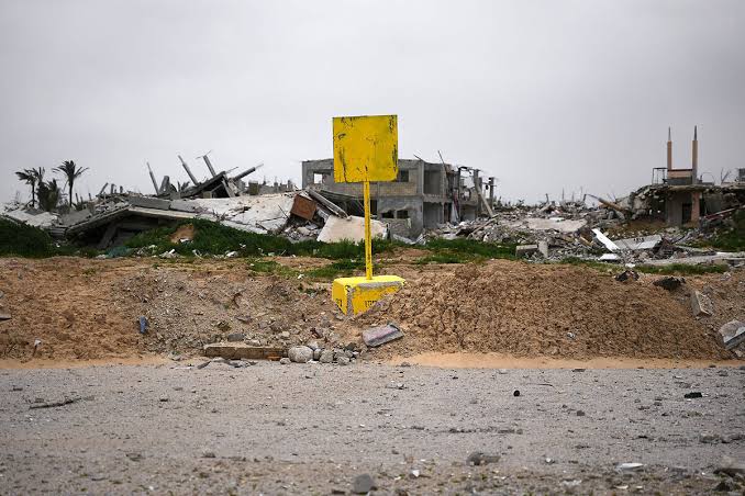
Gaza (QNN)- New maps of Gaza quietly issued by Israel more than a month ago show that its forces have expanded the areas they occupy beyond the so-called “Yellow Line”, a non-physical demarcation line separating the forces deployment from certain areas of Gaza.
The restricted area, marked on the maps with an orange line, makes up an estimated 11% of Gaza's territory beyond the "Yellow Line" demarcating the part of Gaza occupied by Israeli forces since the October ceasefire. The areas cordon off nearly two-thirds of Gaza's territory in total.
Israel's military sent the maps to aid groups in Gaza in mid-March, two aid sources told Reuters, but has not released them publicly.
The two aid sources, both working in Gaza, said the military originally sent aid groups a map showing an expanded zone beyond the Yellow Line after the October ceasefire. That map was published by groups including UNICEF, but never by the military.
The new map shows the Yellow Line and marks the expanded zone with an orange line.
The yellow line is a non-physical demarcation line separating the Israeli occupation forces deployment from certain areas of Gaza, while occupying more than half of the Strip. The line divides Gaza into two zones: an eastern area under Israeli military control and a western area where Palestinians live, were forcibly displaced to, and are under constant Israeli threat of attacks.
During a visit to the Gaza Strip in December, the Israeli military’s chief of staff, Eyal Zamir, said unequivocally that the “Yellow Line” is “a new border line”.
Haaretz previously reported that the Israeli military is turning the “yellow line” into a physical border, despite it being initially intended as a temporary demarcation. The report added that there is currently no detailed mechanism regulating a withdrawal from it.
The two aid sources said that the Yellow Line had moved forward to encompass the original expanded zone, with the orange line marking the boundaries of an even bigger restricted area.
Israel claims the area between the orange line and the yellow line to which its forces withdrew under the October ceasefire agreement is a restricted zone to enable aid delivery, and that aid groups must coordinate their movements with the military.
It claims civilians are not affected.
"In Gaza, more than half of the Strip's territory" is under Israeli control, Netanyahu said in a March 31 video statement.
COGAT, the Israeli military agency that controls access to Gaza, said it had defined areas adjacent to the Yellow Line in which international organizations including humanitarian groups were required to coordinate their movements with the military.
"The boundaries of these areas (the Orange Line), in which coordination is required, are determined and updated in accordance with the operational situational assessment, with the aim of enabling humanitarian activity while safeguarding personnel in a complex operational environment," COGAT said.
However, it was not reported that it communicates the updates to Palestinians.
At least three Palestinians working with foreign aid groups, two with UNICEF, and one with the World Health Organization, have been killed by Israeli attacks in the area between the two lines since mid-March. In both cases, Israel's military claimed it had identified threats near the Yellow Line and had opened fire as a result.
On Friday, UN Secretary-General's Spokesperson Stéphane Dujarric confirmed during a press conference that the “UN has maps showing another colored line called the 'orange line,' which has been provided to UN personnel working in the field of humanitarian aid."
He said that the UN has been informed that humanitarian aid teams must coordinate their movements in advance with the Israeli occupation forces when crossing the "orange line," indicating that areas considered unsafe by the organization are becoming increasingly alarming.
That in effect leaves Israel in control of at least 64% of Gaza, Jad Isaac, director general of the Applied Research Institute-Jerusalem, an independent Palestinian think tank in the occupied West Bank, told Reuters, with the nearly 2 million population almost entirely confined to a sliver of Palestinian-controlled territory along the coast.
"They want to put as many Palestinians as possible in the smallest area in order to drive them out because of the absence of any viability or any sustainability in what's left of Gaza," Isaac said.
On Sunday, Israeli Army Radio said that in recent weeks Israeli occupation forces have pushed the “yellow line” further westward in Gaza and now control approximately 59% of the territory.
Amjad al-Shawa, the head of the Palestinian NGOs Network in Gaza, said the additional line of control had caused confusion and concern.
"Residents do not know where the lines begin or end. One day, the boundary is in one location, and the next day it shifts without warning," Shawa said.
Last week, the Guardian also reported that Israeli forces have advanced the so-called “yellow line” westward across Gaza over the six months since the ceasefire, expanding their control and confining Palestinians to restricted areas. The latest advance was reported overnight along Salah al-Din Street, making the state of limbo ever more dangerous for Palestinians.
The yellow line has crept forward in several places, expanding the forces-controlled area well beyond the 53% of Gaza territory implied in the original ceasefire maps, according to The Guardian.
According to the research agency Forensic Architecture, by December Israel had taken 58% of the strip and continued to edge forwards.
The line is marked in some places by yellow concrete blocks, many of which were moved in December and January as the army took more territory, particularly in urban areas. All over Gaza, residents awoke to find the line had moved overnight and they were suddenly in a free-fire zone.
The forces have also extended a chain of earth berms – raised areas of land – along the line, dominating neighbourhoods and giving tank gunners and snipers a line of sight over large tracts of ruined Palestinian cities. More than 10 miles of berms have been erected already, according to Haaretz, mostly in the north, but bulldozers have started putting up new earthworks in Gaza City and Khan Younis.
The military has been also building an expanding array of fortified outposts. Seven new concrete forts have been built in recent months, bringing the total across the strip to 32. All of the new construction has been along the yellow line, Haaretz said.
As these physical markers have moved westwards, so too has an unmarked zone in which any Palestinian person or vehicle is considered a threat and a legitimate target.
Aid organizations working in Gaza said they were told by Israeli liaison officers that the edge of this zone was the “orange line” and they had to coordinate their operations with the military if they crossed it.
But the orange line existed only on maps. It was never marked and its distance from the yellow line appears to vary from 200 to 500 metres, according to the Israeli army unit deployed there, The Guardian said.
The UN reported in March that it had been informed that the orange line had moved forward and 10 UN facilities were now on the wrong side of it, including emergency shelters for displaced people.
More recently, three connected berms have been erected along the yellow line by Beit Lahiya, forming a high barrier visible from miles around.
The claim that civilians have been killed when they were perceived as a threat to Israeli positions along the line has been rejected as a legal defence by the UN human rights commissioner, Volker Türk, who said this month: “Targeting civilians not taking direct part in hostilities is a war crime, regardless of their proximity to deployment lines.”
Of the more than 800 Palestinians killed by Israeli fire over the six months of the ceasefire, 269 were shot near the yellow line, according to UN data. Of these, more than 100 were children.
About two weeks ago, residents and local journalists reported that Salah al-Din Street, linking northern and southern Gaza, had become increasingly dangerous amid an intensified Israeli military presence, with tanks reportedly advancing in the area.
Eyewitnesses said yellow concrete blocks were installed overnight near Kuwait Junction along the same road, further restricting movement and posing risks to both vehicles and pedestrians.